


National Weather Service Reveals Winter Outlook for Every US Region
National Weather Service Reveals Winter Outlook for Every US Region

Jenny LyntonThu, September 17, 2026 at 5:29 PM UTC
17
Winter is still a few months away, but the National Weather Service‘s Climate Prediction Center has already put out its outlook showing what could be in store across the country. The new maps were published on the morning of Thursday, Sept. 17, and they cover December, January and February, the three months that make up meteorological winter.
There’s plenty of time for things to change between now and then, but the maps give us something to work with as the colder months approach, and El Niño is a big part of what they show.
The Southwest Is the One Region Neither Map Works Against
Snow needs moisture and cold at the same time to form, and the Southwest is the only place where neither map points in an unfavorable direction for snow.
The precipitation outlook favors above-normal precipitation across the whole southern tier. This stretches from coastal California through Arizona, New Mexico and Texas, along the Gulf and up to almost the entire East Coast. On the temperature map, Nevada, Utah, Colorado, Arizona and New Mexico are left blank and marked as having equal chances, meaning forecasters see no preference between a warm, normal or cold winter there.
Those same states sit under the wet shading. At elevation, in Utah’s Wasatch, Colorado’s San Juans and the high country of northern Arizona and New Mexico, that pairing is what builds a snowpack.
That’s also as close to cold as this forecast gets. An equal-chances forecast doesn’t mean a cold winter is expected. It simply means NOAA sees no clear preference for warmer or colder-than-normal temperatures. No part of the Lower 48 is shaded for below-normal temperatures.
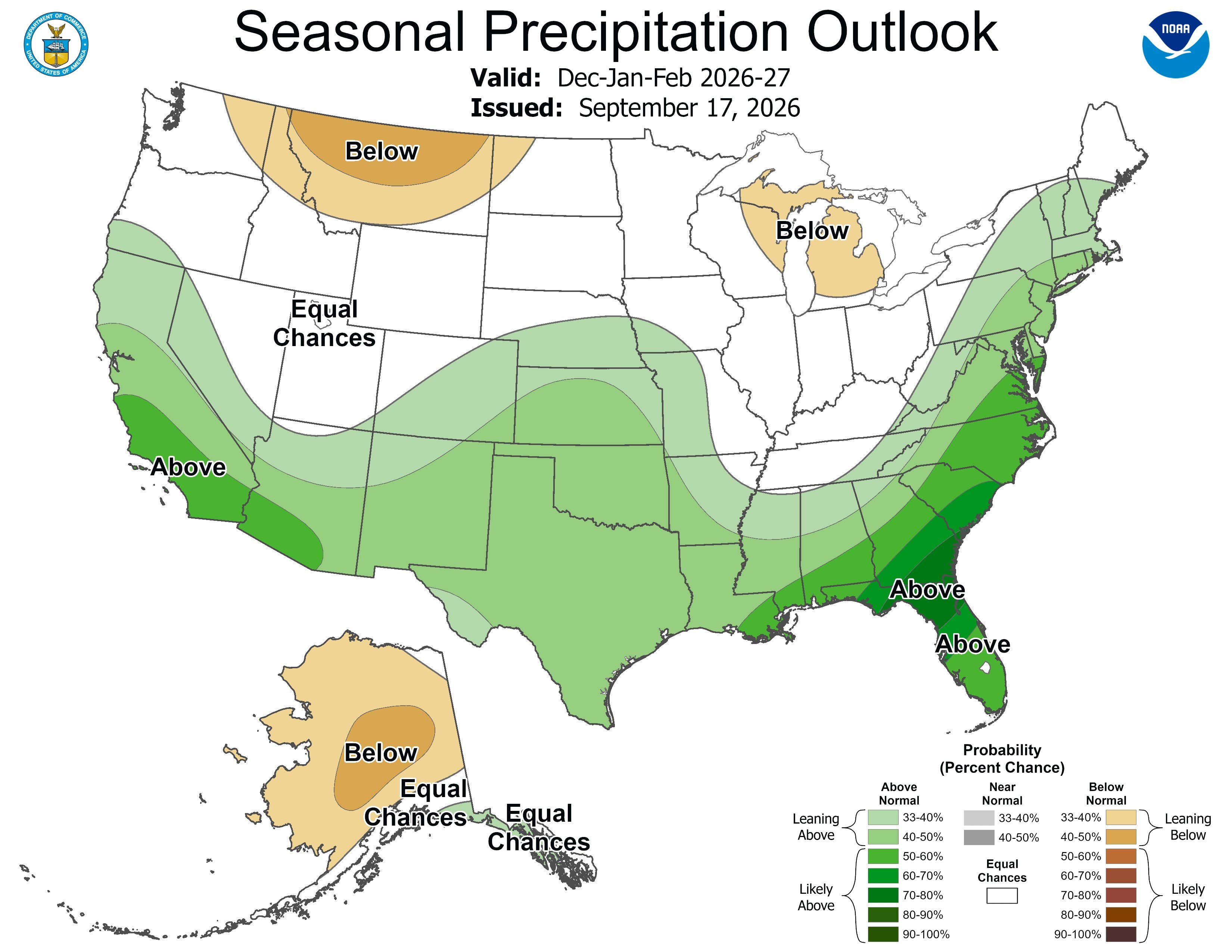
NOAA’s precipitation outlook for December, January and February, issued Sept. 17. Green favors above normal, tan below normal, white equal chances.NOAA Climate Prediction Center
View the 2 images of this gallery on the original article
The Southeast Is Wet, and That’s the Bigger Story
The Southeast and the Gulf Coast carry the strongest precipitation signal in the country. On the new map, the deepest shading over southern Georgia, northern Florida and the peninsula sits in the 70 to 80 percent range.
Temperatures there are shaded near normal rather than below, so this is not a snow forecast. Rain is the main story, with ice possible when the vertical temperature profile lines up.
The wet tilt continues up almost the whole East Coast into New England, although the Northeast also carries some of the deepest warm shading on the temperature map.
The Northwest and the Great Lakes Lean Dry
The Pacific Northwest and the northern Rockies are on the dry side of the precipitation map and under some of the deepest warm shading on the temperature map. A second dry area sits over Michigan and the Great Lakes, under the same warm shading.
That matters because these are the regions people picture when they think about a snowy winter.
Advertisement
One thing to keep in mind while reading any of this. These maps show departures from normal, not absolute conditions. A winter that leans above normal in Minnesota or Maine is still a cold, snowy winter by any other standard, and those states can finish with more snow than Arizona while sitting under warm shading. The maps show how each region is tilted relative to its own climate history, rather than which places will end up with the most snow on the ground.
Everywhere Else, the Map Declines to Lean
Large parts of the country carry no signal at all. The northern Plains and the Dakotas show no precipitation signal. This means NOAA is declining to call it either way in the region that usually anchors the country’s snow season. The Ohio and Tennessee valleys are blank too. Texas and the southern Plains lean wet, but only slightly, at the edge of the southern tier band. Across all of them, temperatures tilt above normal.
Alaska splits, with the mainland leaning dry through these three months and the southeast staying warm.
El Niño Is Still Getting Stronger
The Climate Prediction Center’s September 10 update raised the odds of a record-setting event for October through December to 75 percent. This is measured against a three-month RONI value of plus 2.5 degrees Celsius or higher. Its summary reads:
El Niño is strengthening, with a greater than 90% chance of a very strong event during the Northern Hemisphere fall and winter 2026-27.
Sea surface temperatures in the eastern equatorial Pacific are running more than 3 degrees Celsius above average.
How It Moved Since August
Two things changed between the Aug. 20 maps and these, at opposite ends of the country.
In the Southeast, the deepest shading stopped at 60 to 70 percent last month. The new map adds a 70 to 80 percent band over southern Georgia, northern Florida and the peninsula. This level was not shown on the December through February outlook anywhere in August.
In California, 50 to 60 percent shading on the map included a narrow strip running from the south of the state across to southwestern Arizona. Now it reaches much farther north and inland, putting more moisture over the Sierra. Despite this, temperatures there still lean above normal.
Everything between them held, including the dry pockets, the blank northern Plains and the temperature map. The next set comes out Oct. 15.
This story was originally published by Men's Journal on Sep 17, 2026, where it first appeared in the News section. Add Men's Journal as a Preferred Source by clicking here.
Source: “AOL Breaking”
